

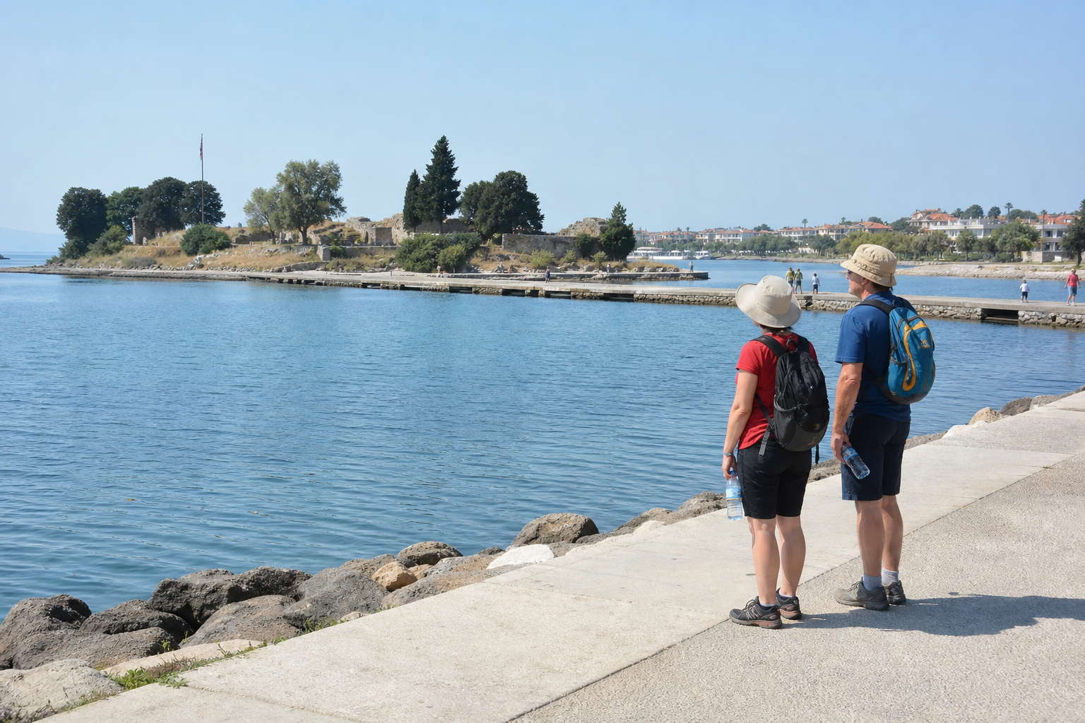
Urla İskele is not a single archaeological stop but a fragmented coastal archive in which a low promontory, a changed shoreline, a modern road and an operational island hold parts of one long story. The corridor brings together Limantepe’s prehistoric occupation, the Ionian city of Klazomenai, evidence of ancient production and Karantina Island’s later quarantine role. Its value lies in those overlaps, as well as in the practical limits they place on what can be entered, seen or confirmed during a visit.
The corridor lies in Urla’s İskele neighbourhood, on İzmir Bay’s coastal plain. A walk along today’s waterfront does not provide a direct view of the ancient harbour landscape. Research records that Middle Holocene sea conditions reached roughly one kilometre inland of the present coast, while later sedimentation formed the plain surrounding the modern shore. The coast should therefore be read as a landscape that has physically changed, rather than as an ancient harbour simply concealed by recent development.
Why Urla İskele matters now
Limantepe is a low coastal promontory, about 13 metres high, but its occupation sequence is unusually deep. Research identifies settlement from the Chalcolithic through the Late Bronze Age, followed by Iron Age continuity as Klazomenai. It was settled from the Bronze Age and later formed part of Klazomenai’s urban landscape. That chronology matters because it prevents the place from being reduced to a classical Greek label: the Ionian city is one phase in a much longer history of settlement on the same coastal ground.
Klazomenai was one of the twelve Ionian cities, and its documented extent reaches well beyond a single visible monument. The official account of Klazomenai places the city from Limantepe across Karantina Island and towards the Ayyıldız and Cankurtaran hills. This is consequently a dispersed landscape rather than an open-air archaeological park. Its evidence is spread across road-divided land, underwater areas and an island that also has a current administrative function.
Historical development and turning points
The long sequence at Limantepe gives the corridor its chronological depth. Chalcolithic, Bronze Age and Iron Age phases show continuity of occupation, while the Iron Age connection to Klazomenai places the site within the Ionian world. The shift is important, but it was not a clean replacement of one place by another. Limantepe remained part of the urban landscape associated with Klazomenai, linking the earlier settlement record with the city’s later coastal development.
Archaeological work has continued uninterrupted at Limantepe since 1992, according to the Ministry’s excavation record, and extends into the sea. Underwater work is central to the site’s interpretation because the settlement history, harbour setting and changing coast cannot be separated. Ongoing excavation also has an immediate practical consequence: terrain under investigation should not be treated as ordinary public space simply because it lies close to an inhabited waterfront neighbourhood.
How the corridor is shaped by coast, road and production
The İzmir–Çeşmealtı road divides the harbour area associated with the prehistoric and classical settlement. That division affects how the place is experienced today. A visitor encounters separated pieces of a historical setting rather than a continuous, legible harbour edge. Combined with the shoreline changes that created the present plain, the road makes a straightforward attempt to trace an ancient waterfront on foot unreliable.
At Hamdi Balaban Field in İskele, the Klazomenai olive-oil workshop is a reconstruction project developed after excavation work in 2004–05. It relates to evidence for a sixth-century BCE rock-cut workshop with 15 pits. The Klazomenai documentation connects that production evidence to export-oriented olive-oil and wine trade. The workshop is therefore more than a reference to regional food culture: it helps explain production technology and the external commerce of an Ionian coastal city.
Current management and operations
Karantina Island adds a later institutional layer to the corridor. Its quarantine buildings processed arriving travellers through disinfection, bathing and medical examination, as described in Urla Municipality’s history of Karantina. The sequence makes the island part of the history of maritime movement, but from the perspective of controlled passage and health inspection rather than unrestricted circulation along the coast.
That institutional dimension has not disappeared. The Ministry of Health’s organisational listing registers the Urla Karantina Island Directorate at Karantina Island. Historical interest is not the same as confirmed public access: the island’s active health-administration role creates a practical boundary between heritage interest and institutional property. Visitors should not assume entry to the island, the quarantine buildings or excavation terrain without confirmed arrangements.
Access, surroundings and neighbourhood impact
Public transport reaches Urla via ESHOT route 984 between Urla and Fahrettin Altay Transfer Centre. Because service intervals, stop patterns and temporary diversions can change, check ESHOT’s current timetable before departure rather than planning around a fixed end-to-end duration. For this corridor, allow generous time for walking and for access restrictions around excavation or institutional areas.
Before travelling, check departures and possible diversions, as temporary changes can affect Urla services. The more useful choice is to allow time for a deliberate visit and rely on public waterfront viewing when access to the island, excavation areas or workshop operations is unconfirmed. The reconstructed workshop’s current hours, admission arrangements and operating status are not robustly confirmed and should be checked directly. In summer, account for exposed roadside and waterfront walking despite Urla’s regular coastal breeze.
Near-term changes and consequences
There is no basis for treating the corridor as a fixed visitor product. Limantepe remains under active land and underwater excavation, while Karantina Island continues to host health administration. These continuing functions can limit heritage visibility and access at any given time. They also explain why the area cannot safely be presented as a continuously accessible route, even though its elements belong to the same coastal history.
The practical consequence is to approach the corridor as connected but unevenly accessible. Use the waterfront to understand the altered coastal setting; treat the workshop as a historically significant reconstruction whose operations require confirmation; and regard Karantina Island as a place where quarantine history and current administration coexist. Urla İskele rewards that slower reading: prehistoric settlement, Ionian production, quarantine infrastructure and present-day public responsibility remain on one shore, but they are not all available to visitors in the same way.
Sources
- moovitapp.com
- izmir.ktb.gov.tr
- izmir.ktb.gov.tr
- Bağlı Birimler Teşkilat Yapısı
- Limantepe Ören Yeri Kazısı / Urla
- URLA-İSKELE KIYI DÜZLÜĞÜNÜN HOLOSEN PALEOCOĞRAFYASI VE JEOARKEOLOJİK DEĞERLENDİRMELER – Ege Coğrafya Dergisi
- Secrets Buried in the Pits: Ritual Activities in Western Anatolia in the First Half of the Second Millennium bce | Cambridge Archaeological Journal | Cambridge Core
- About Visit Izmir
- Urla Belediyesi | Urla urla karantina
- ESHOT Urla’da güzergah değiştiriyor: Bu duraklar hizmet dışı kalacak – İz Gazete – İzmir Haberleri – Son Dakika Haberler